Lamin Jaiteh talks about his MSc thesis in which he planned and organized a national surface water monitoring scheme for his home country The Gambia, West Africa, where it is intended to be implemented to improve water quality and protect natural resources.
The Master thesis was conducted within the MAGIC research team, supported by Lara L. Petschick, and supervised by Prof Dr. Ralf Schulz and Dr. Sebastian Stehle at the University of Koblenz-Landau, Institute for Environmental Sciences. The project received further support by the SystemLink working group. Special mentions are the expert support by Dr. Peter Alexis Roodt (SystemLink) and Prof. Dr. Ralf Schulz.
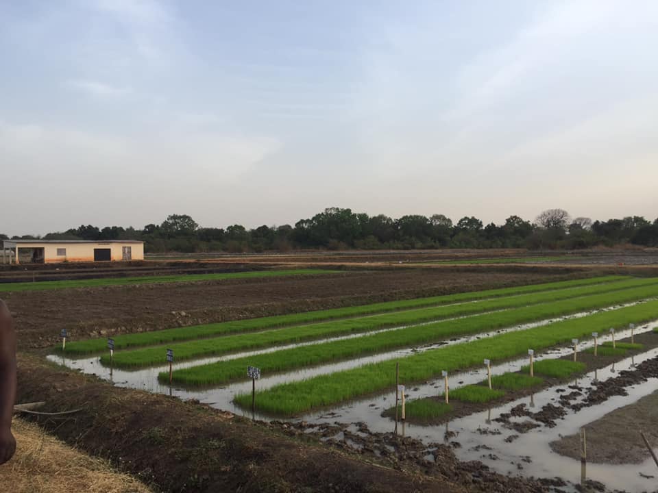
The Gambia, being the smallest in-land country in Africa, is located in West Africa with a total land area of 11,300 km2 out of which 1,300 km2 makes up its surface water (marine, river, estuaries, tributaries, and others). Bordered by Senegal from the North, East, and South and from the West by the Atlantic Ocean, the country is distinctively described by its river called “River Gambia”, emerging from Fouta Djallon highlands in Guinea Conakry. Based on the recent national population census from 2013, the total population of the country is approximately 1.9 million, with 61.3% of the population residing in the urban area, while 38.7% reside in the rural area. Approximately a quarter of the total population of the country are farmers, and agriculture accounts for 27% of the total Growth Domestic Product (GDP) of the country. Thus, agricultural use of pesticides (i.e., herbicides, insecticides, fungicides) in The Gambia supersedes all other forms of chemical uses.
Other sources of pollutants within the country emanate from point sources such as wastewater treatment facilities, open discharge of residential effluents, opened communal dumps, food processing facilities, soap manufacturing facilities, plastic molding installations, and others. These sources represent the two usual main sources of pollutants into surface water (i.e., via diffuse and point sources). Pollutants such as pesticides and heavy metals impair the integrity and ecosystem functions of surface water bodies globally. Other complex stressors such as climatic factors, land use, landscape, and soil characteristics, are also known to exacerbate the introduction of pollutants into surface water bodies.
While some regions have studied their surface water systems extensively within the last decades (e.g., EU and US), monitoring programs are still limited in other areas (e.g., West Africa). Despite evidence of diffuse and point source introduction of pollutants in the Gambian surface waters, there is no established surface water monitoring program. Overall, this scheme is intended to setting up a roadmap to obtaining measured concentrations of target substances in The Gambian surface water bodies. If a substantive amount of toxicity information is obtained from the intended chemical monitoring program, such data will be useful in developing effective mitigation measures to minimize pollutant exposure in surface waters within the country.
Retrospective and Current Use of Pesticides in The Gambia
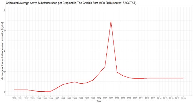
Pesticide formulations such as Fernasan-D (thiram and lindane), Aldrex-T (thiraldin), Actellic Dust (primiphos-methyl) and active substances such as propuxor and dieldrin have been used by farmers in the country since independence in 1965, mainly as grants by the Government of The Gambia. The Ministry of Health reintroduced DDT in 2010 to contain malaria outbreaks in the country, through a nationwide campaign using indoor residual spraying. However, the National Malaria Control Programme (NMCP) has recently substituted DDT with deltamethrin. Current use compounds listed in the national registry comprise approximately 99 active substances, mainly pyrethroids, carbamates, organochlorines, and others, which are approved in consultation with the regional pesticides approval board called the Sahelian Pesticide Committee (SPC) within the CILSS member states. Despite the many regulations in the country, The Gambia continues to record above average used active substance per hectare of arable agricultural land compared to other low income countries in the region.
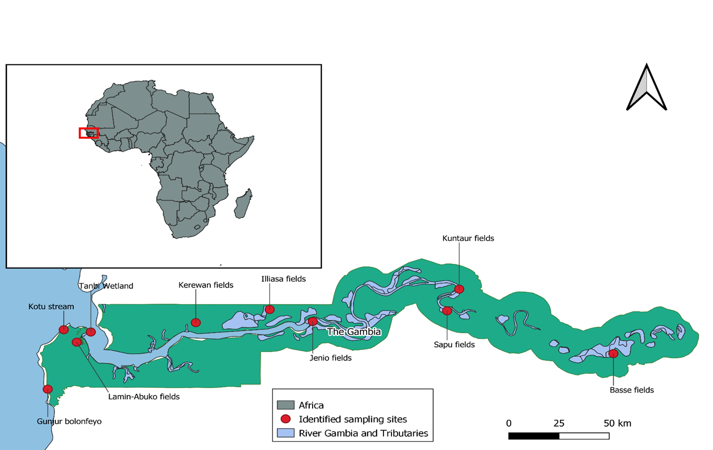
Potential sampling sites in The Gambia
The present study identified 10 potential sampling sites referred to as hotspots within the country. The potential sampling sites were selected using the following criteria:
- Presence of agricultural activities (with evidence of pesticide use) within the vicinity
- Presence of potential point sources
- Distribution among the country to sample a gradient
To gather further information about the potential sites, consultation with the National Environment Agency of The Gambia Regional Officers was held. Sites were selected based on the acquired information and known land use characteristics. Presence of surface water bodies near the hotspots was verified using satellite images and expert knowledge about the sites.
A total of 10 potential sampling sites were identified from the surface water bodies in The Gambia. Four (4) of these sites are natural streams located within the Greater Banjul Area (GBA) and West Coast Region (WCR) (i.e., Tanbi wetlands, Kotu stream, Lamin-Abuko fields, and Gunjur bolongfeho). The remaining six (6) selected sampling sites are located in the rural Gambian area (i.e., Sapu fields in Central River Region (CRR), Kerewan fields in North Bank Region (NBR), Jenoi fields in Lower River Region (LRR), Kuntaur fields in CRR, Basse fields in Upper River Region (URR), and Illiassa fields in NBR).
Population distributions around the potential sampling sites were retrieved and aggregated based on the settlements near the identified sampling sites. Population data were obtained from The Gambia Bureau of Statistics (GBOS) and processed with the assumption that settlements near these sampling sites are likely farming in the nearby agricultural fields. The urban areas of the country recorded the highest total population distribution, and land use in those areas is characterized by agricultural, residential and industrial activities. Despite the low population density and distribution in the rural area of the country, agricultural practices still strive in those areas, likely representing diffuse sources of pesticide pollution.
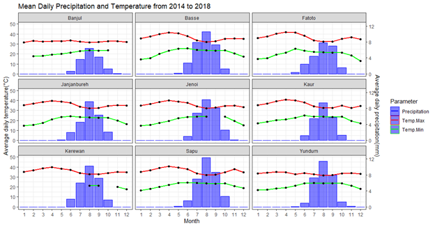
Time series precipitation and air temperature data were acquired to deduce the best possible sampling time in The Gambia from the potentially identified sampling sites. Precipitation and temperature data recorded from nine (9) weather stations across the country was provided and analyzed to determine the average daily precipitation per station from 2014 to 2018. The Gambia observes two seasons; the dry season (November to April) and the rainy season (May to October). Based on the raw data collected from the Department of Water Resources of The Gambia recorded from the nine (9) weather stations across the country from 2014 to 2018, highest average daily precipitation was observed in August with maximum mean daily rainfall of 12.14 mm. Non-parametric statistical hypothesis testing showed that there was no statistically significant difference in the average daily precipitations recorded per weather station from 2014 to 2018 (Kruskal-Wallis rank sum test: chi-squared = 0.3021, df = 8, p > 0.05). Air temperature recorded and analyzed showed that the highest daily average temperatures are usually recorded in April (41.94 oC) and minimum average daily temperatures in December (12.97 oC).
Proposed sampling methods
A comprehensive literature review on current sampling methods from surface water bodies was done to identify the most appropriate sampling methods taking into consideration the current circumstances, opportunities, and drawbacks within The Gambia. These were complemented with field training at surface water monitoring stations around Landau in der Pfalz (with the project, University of Koblenz-Landau). Sampling strategies in this monitoring largely depend on our target analytes that are pesticide active substances approved and traded in The Gambia.
Notably, three (3) sampling methods were decided on: grab sampling (GS), event-driven sampling (EDS), and passive sampling (PS) to sample from the identified sampling sites. GS is the simplest water sampling technique where water samples will be physically grabbed from a sampling stream or agricultural field using 1-liter glass amber bottles. In this approach, the glass bottles will be fully submerged in the flowing stream pointing against the current of the stream. The sampling bottles will be submerged at a depth of approximately 100 mm to collect samples, and capped under water to avoid any air being trapped. The samples will be stored on ice and transported to the laboratory immediately. In the laboratory, the samples will be stored in the refrigerator at 4 oC before extractions. Although GS is a simple method, it is an effective approach to capture spot concentration of pesticides.
EDS is an uncomplicated method aimed to capture peak concentrations of pesticide exposure in lotic systems. Like GS, the setup will follow the approach described in Schulz et al. (2001) and in Schäfer et al. (2008) and will be adapted based on the local and cheap materials available to sample surface water during episodic rainfall events. The whole setup will be designed with two equal-sized glass amber bottles able to contain a total volume of 1 Liter of water samples each. The sampling bottles will be tightly strapped adjacent to each other to a single holding iron rod. The bottles will be deployed slightly opened with the lids loosely placed over the bottle opening and strapped with plastic tightening straps to ensure that the lid does not fall off and ensure that flying objects such as insects, leaves, and dust from entering the sampling bottles.
Passive sampling with Chemcatcher® is designed with two major components, the receiving disk and a diffusion membrane used to capture time-weighted concentrations of pollutants. The kinetics of sampling with PS in aquatic systems is determined by the concentration of the analyte in water, concentration in the diffusive membrane, and the concentration in the receiving disks.
These sampling methods have been selected to capture concentrations of pollutants in surface waters covering different concentration scenarios (i.e., time-weighted concentrations, peak concentrations, and spot concentrations of pollutants and their transformation products). The three sampling strategies are intended to gain an understanding of the pollution spectrum of surface water bodies in The Gambia, not only sampling and analyzing the target compounds.
Expectations for the monitoring program
- The monitoring is expected to give national baseline information on surface water contaminants across the country
- The study will reveal the adaptability and precision of the sampling methods to be implemented in our national situation
- Due to our weak enforcement systems to regulate chemical trade within the region, this study will unveil if banned and restricted pesticides are still in circulation in the agricultural settings
- The study is expected to lead us into developing appropriate mitigation measures to ensure that primary users of pesticides would implore sound management of pesticides through the adoption of best practices
- The study is also expected to lead us into further research adventures and transfer of knowledge with parties. Special mentions are the expert support by Prof. Dr. Ralf Schulz and Team